 By Bruce Ross, Executive Director bruceross@wi.rr.com
This article originally appeared in Wisconsin Waterfowl Association’s October, 2020 Newsletter edition.
We’ve been receiving some questions from members wondering why they are seeing changes to the refuges in the vicinity of their hunting grounds. Here’s why.
In 2019, the DNR undertook its first refuge/closed area review in 40 years that included 270 properties around the state. WWA was notified by the DNR that this review was happening, and they invited us to comment. But we couldn’t really do justice to such a review since we don’t have comprehensive knowledge on each possible location or proposed change. So we didn’t take a position on the specifics of the change, on the 270 properties.
Instead, WWA advertised this ongoing review in our newsletter (August 2019) and our Facebook pages. We thought the timeline for public review was too short, so we asked the DNR to delay their process to allow our members to consider the changes…. And the DNR did delay (by several weeks) this step in the process. We also thought that it would be important to summarize the changes for each location so readers would be better able to understand what was being proposed – and again, the DNR did just that. After the extended deadline for public comment, the Natural Resources Board did approve it. The WWA newsletter last month also mentioned these changes under Taylor Finger’s presentation from the Waterfowl Summit, including a couple of slides from his presentation that speak to this topic (very generally).
Here’s the summary and the presentation the DNR gave to the NRB when they considered it.
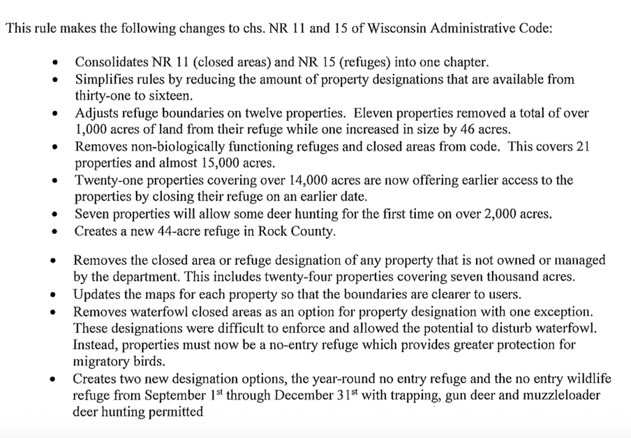
In addition to adjusting boundaries based on public input, as well as input from their wildlife area managers and technicians, the DNR simplified the reasons for refuge management, took several closed areas/refuges off-the-books, and changed some timeframes for date-specific closure. In a general summary:
- 3,000 acres of important stopover area remains protected.
- The DNR removed 22,000 acres of closed/refuge that was no longer warranted, opening these lands up for increased use, including hunting.
- They also updated all the refuge/closed area mapping to be useful in today’s digital age. It’s not clear to WWA whether the DNR’s digital public land mapping apps have been updated for all these changes yet, but they’re working on it – when in doubt, check DNR regulations in NR 11 for the updated maps.
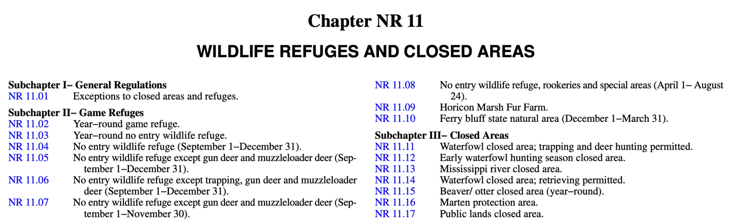
- For the specifics of the changes to any particular property, you’ll have to look at WI regulations section NR 11.
- Below is the title page for the NR 11 regulations. It’s not entirely intuitive (at least not to me), but the categories of each type of refuge and closed areas are shown under the respective subchapters. What this means is that if you don’t see your refuge or closed area under the first category (NR 11.02 for example), keep looking in the other categories.
Some of the feedback we’ve received in the past few weeks has not been favorable to the changes. If you have an issue, WWA encourages you to communicate with your local wildlife area manager responsible for the refuge. I do know that Taylor Finger has specifically said it will not be another 40 years until the DNR revisits the refuges/closed area issue again. If the changes do not accomplish the purpose the DNR intends, I’m confident they will revisit the decisions taken through the formal rule-making process. Bear in mind that it’s nearly impossible to determine whether the goals have been achieved or not from a single season. Keep us informed on your discussions.